SCHEDULE 1
Regulation 4(b)
SCHEDULE 1
RESTRICTED AREAS |
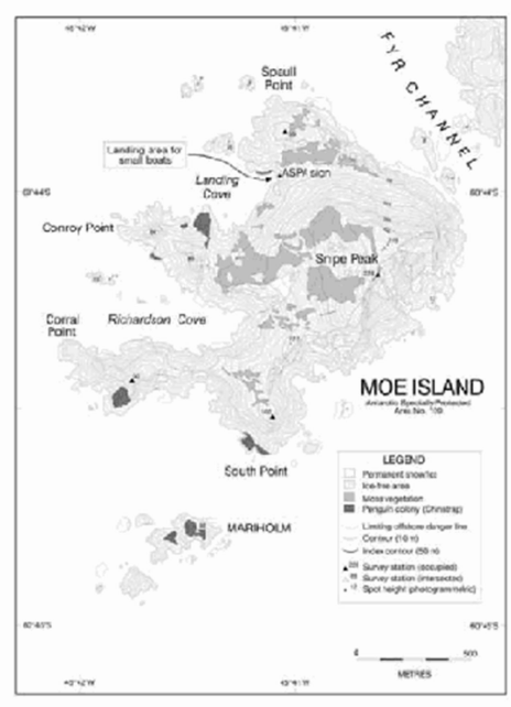
Antarctic Specially Protected Area No. 109 |
Moe Island, South Orkney Islands |
Lat: 60°44′S; Long: 45°41′E |
Moe Island is a small irregularly-shaped island lying 300 metres off the south-western extremity of Signy Island from which it is separated by the Fyr Channel. Moe Island is approximately 1.3 kilometres from northeast to southwest and 1km from northwest to southeast.
Map: ASPA No. 109: Moe Island
Map specifications: Projection: WGS84 Antarctic Polar Stereographic. Standard parallel: 71°S. Central meridian 45°W.
RESTRICTED AREAS |
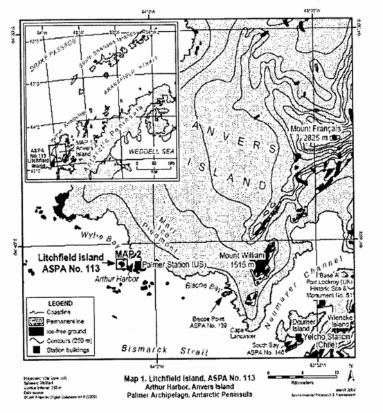
Antarctic Specially Protected Area No. 113 |
Litchfield Island, Arthur Harbour, Anvers Island, Palmer Archipelago |
Lat: 64°46′S; Long: 64°05′ W |
Litchfield Island (0.35 square kilometres) is situated in Arthur Harbour approximately 1500 metres west of Palmer Station (United States). The island measures approximately 1000 metres northwest to southeast and 700 metres from northeast to southwest. It has the most varied topography and greatest diversity of terrestrial habitats of the islands in Arthur Harbour. The area is defined as all of Litchfield Island above the low tide water level excluding all offshore islets and rocks. No boundary markers have been installed as the coast is clearly defined and is a visually obvious boundary feature.
Map 1: ASPA No. 113: Litchfield Island
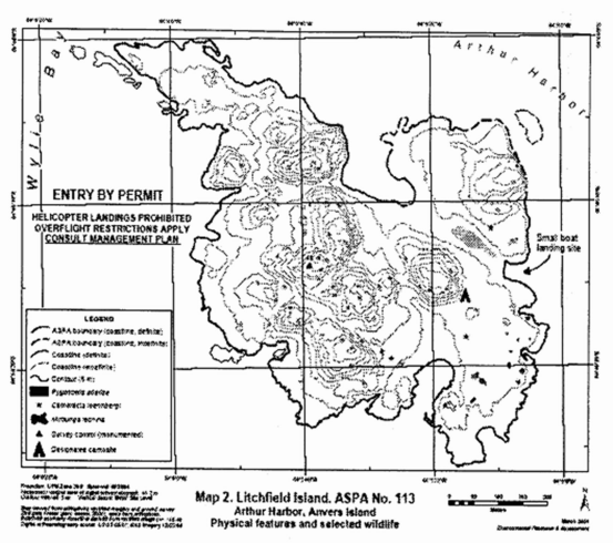
Map 2: ASPA No. 113 Litchfield Island
RESTRICTED AREAS |
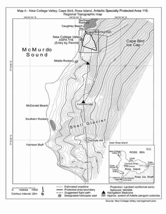
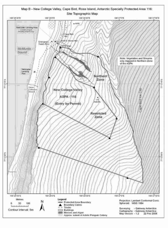
Antarctic Specially Protected Area No. 116 |
New College Valley, Caughley Beach, Cape Bird, Ross Island |
Lat: 77°13′S; Long: 166°26′30″E |
New College Valley is located south of Cape Bird on ice-free slopes above Caughley Beach which lies between the Cape Bird Northern and Middle Rookeries. The boundaries of the area follow the ridges enclosing the catchment of the New College Valley.
Map 1: ASPA 116: New College Valley
Map 2: ASPA No. 116: New College Valley
RESTRICTED AREAS |
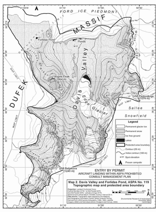
Antarctic Specially Protected Area No. 119 |
Davis Valley and Forlidas Pond, Dufek Massif, Pensacola Mountains |
Lat: 82°27′S; Long: 51°05′W (Davis Valley) |
Lat: 82°27′S; Long: 51°16′W (Forlidas Pool) |
The Area comprises all of the Davis Valley and includes the entire ice-free region centred on the Valley, including the immediately adjacent ice-free valleys and Floridas Pond and encompasses a total area of 57.2 square kilometres. Boundary markers have not been installed but the boundary predominantly follows the margins of the surrounding ice fields of the Ford Ice Piedmont and Sallee Snowfield.
Map: ASPA No. 119: Davis Valley and Floridas Pond
RESTRICTED AREAS |
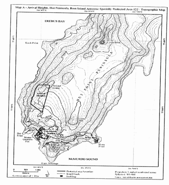
Antarctic Specially Protected Area No. 122 |
Arrival Heights, Hut Point Peninsula, Ross Island |
Lat: 77°49′S; Long: 166°40′ E |
Arrival Heights is a small range of low hills near the southeast end of Hut Point Peninsula, South East Ross Island, 1.5 kilometres north of McMurdo Station and 3 kilometres north of Scott Base. It is formed by a line of craters that extend south from the flanks of Mount Erebus. The highest elevation within the Area is Second Crater at 255 metres, one of two inactive volcanoes that are a part of the boundaries of the Area. The boundaries of the Area extend in a straight line from Trig T510 Northwest over First Crater to the 150 metre contour. The boundary extends east to Second Crater, the lip of which forms the northeast corner of the area. The boundary then extends south in a straight line to Trig T510.
Map: ASPA No. 122: Arrival Heights
RESTRICTED AREAS |
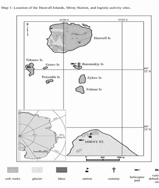
Antarctic Specially Protected Area No. 127 |
Haswell Island (and Adjacent Emperor Penguin Rookery on Fast Ice), David Sea |
Lat: 66°31′S; Long: 93°00′E |
The Area consists of Haswell Island (approximately 1 square kilometre) and its littoral zone and the adjacent section of fast ice in the Davis Sea (the fast ice is approximately 5 square kilometres when present). This is a unique breeding site for almost all breeding bird species in East Antarctica.
Map: ASPA No. 127: Haswell Island
RESTRICTED AREAS |
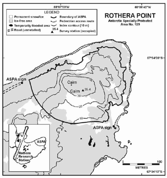
Antarctic Specially Protected Area No. 129 |
Rothera Point, Adelaide Island |
Lat: 67°34′S; Long: 68°08′W |
Rothera Point is situated in Ryder Bay at the south-east corner of Wright Peninsula on the east side of Adelaide Island south-west Antarctic Peninsula.
The Area is the northern one-third of Rothera Point extending approximately 280 metres from west to east and 230 metres from north to south, rising to a maximum height of 36 metres. At the coast the boundary is the 5 metre contour (formerly the 2.5 metre contour). The Area does not include any upper shore, littoral or sub-littoral areas of Rothera Point. The southern boundary of the Area runs across Rothera Point and is partially marked by rock filled gabions. Rothera Research Station (United Kingdom) lies approximately 250 metres west of the western boundary.
Map: ASPA No. 129: Rothera Point
Map specifications: Projection: WGS84 Antarctic Polar Stereographic. Standard parallel: 71°S. Central meridian 67°45′W.
RESTRICTED AREAS |
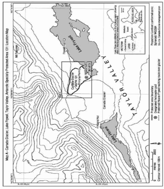
Antarctic Specially Protected Area No. 131 |
Canada Glacier, Lake Fryxell, Taylor Valley, Victoria Land |
Lat: 77°37′S; Long: 163°03′E |
Canada Glacier is situated in the Taylor Valley, in the southern Victoria Land Dry Valleys. The Area encompasses most of the glacier forefield area on the east side of the lower Canada Glacier, on the north shore of Lake Fryxell. It contains some of the richest plant growth (bryophytes and algae) in the southern Victoria Land Dry Valleys.
Map: ASPA No. 131: Canada Glacier
RESTRICTED AREAS |
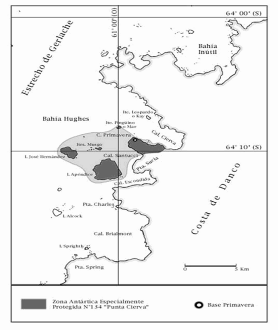
Antarctic Specially Protected Area No. 134 |
Cierva Point and Offshore Islands, Danco coast, Antarctic Peninsula |
Lat: 64°09′S; Long: 60°57′W |
Cierva Point was designated on the basis of its well developed maritime vegetation and breeding colonies of a variety of bird species. It is located in the south coast of Cierva Cove to the north of Hughes Bay. The site comprises the ice-free area between the southwest coast of Cierva Cove and the northeast coast of Santucci Cove and also includes Apendice and Jose Hernandez Islands and the Moss and Penguin Islands. The inter-tidal zone of these areas is also included but not the sub-tidal marine environment.
Map: ASPA No. 134: Cierva Point
RESTRICTED AREAS |
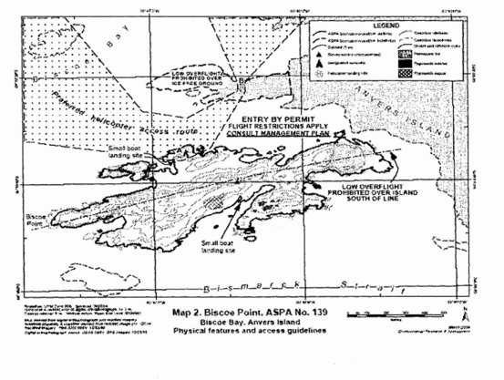
Antarctic Specially Protected Area No. 139 |
Biscoe Point, Anvers Island, Palmer Archipelago |
Lat: 64°48′S; Long: 63°47′ W |
Bisco Point is at the western extremity of a small island located close to the southern coast of Anvers Island approximately 6 kilometres south of Mount William. This island is separated from Anvers Island by a 50 metre wide permanent marine channel. The Area is defined to include all land above the low tide water level of the main island on which Biscoe Point is situated (0.53 square kilometres), all offshore islets and rockets within 100 metres of the shore of this main island and most of the predominantly ice-free promontory 300 metres to the north (0.1 square kilometre).
Map 1: ASPA No. 139: Biscoe Point
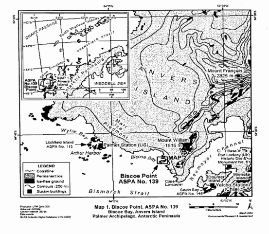
Map 2: ASPA No. 139: Biscoe Point
RESTRICTED AREAS |
Antarctic Specially Protected Area No. 140 |
Parts of Deception Island, South Shetland Islands |
Lat: 62°57′S; Long: 60°38′W |
Deception Island, situated in the Bransfield Strait, is a unique Antarctic island with important natural, scientific, historic, educational and wilderness value. The Area comprises 11 terrestrial sub-sites namely Collins Point; Crater Lake; Unnamed hill at the southern end of Fumarole Bay...
